Flow Calc is a commercialֲ ֲ computer software program designed to calculate common Open Channel Flow hydraulic characteristics using only the methods of the Manning’s Equation for regular and irregular channel geometries for steady uniform flow including circular and elliptical pipes.

Flow Calc


From Flow Calc web site:

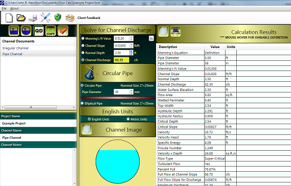
Flow Calc provides an easy to use interface that is streamlined and simplified for both English and SI Units. Extensive efforts were undertaken to provide a single screen interface to provide the most functionality for the design engineer. Effectively this allows the design engineer to monitor and correct channel geometries on the fly while at the same time being able to view the computational results immediately. Along with the data input controls for manual data entry, spin-controls are additionally provided to facilitate design review dynamically. A graphical representation of the channel geometry as entered by the design engineer provides a visual aide of the water surface elevation that is continually adjusted based upon input values.
Free to try, 149.99$ to buy.

Tagged with: ,

Air Water International Corporation sent a press release announcing the install of an Air Water Station in the Jalimudi Village, India:

For the villagers of Jalimudi, a small village in Andhra Pradesh, it is a historic event. They are getting water from the air thanks to modern day technology. Jalimudi is the first village in the world to have a sustained water supply that is not from the sea, river, lake, pipeline, well, or transported by water tankers and trucks.

Tagged with: ,

A Postdoctoral Research position is available in the internationally acclaimed Centre for Water Systems at the University of Exeter, UK under the supervision of Professor David Butler. This research council funded post is available immediately. The successful applicant will work on a number of university consortium projects, principally ג€˜Urban Futuresג€™, but also ג€˜ReVISIONsג€™ and ג€˜Ashfordג€™s Integrative Alternativesג€™, all of which focus on various aspects of sustainable urban water management.

The successful applicant will have responsibility for using and developing a suite of water system modelling tools developed in the Centre. The successful applicant will be able to present information on research progress and outcomes, communicate complex information orally, in writing and electronically and prepare proposals and applications to external bodies.

Applicants will possess or shortly possess a relevant PhD and be able to demonstrate sufficient knowledge of research methods and techniques required for the projects. Applicants must have excellent modelling skills and an interest in the wider water and sustainability agenda. Experience of using appropriate software is important and should ideally include knowledge of Matlab and GIS.

Salary will be up to GBP26,391 pa on the Associate Research Fellow scale, depending on knowledge, skills and experience for two years.

The closing date for completed applications is 20th February 2009.

To apply, please supply a completed application form, a CV and covering letter with the contact details of three referees to Professor Butler quoting the job reference 34067.An application form is here:

http://admin.exeter.ac.uk/personnel/jobs.php?action=job&areaid=4&jid=3725

Tagged with:

The EPA posted a nice fact regarding toilt flushs during the Super Bowlֲ next week:

Consider this: On Super Sunday, February 1, about 90 million people sit down to footballג€™s biggest game. If all of these viewers got up to use the restroom at halftime, the result would be about 300 million gallons flushing in near syncג€”now that’s one super flush! However, if every fan were using a WaterSense labeled toilet, it would only require about one-third of that amountג€”saving nearly 200 million gallons of water, or more than four minutesג€™ flow over Niagara Falls. Looking for the WaterSense label when youג€™re replacing an old, inefficient toilet is just one way you can help to save our nationג€™s water resources; it benefits the environment and doesn’t require any extra effort on your part.

That is a super flush 🙂

Optimatics developed a software tool, named OptiCritical, to assist clients in analyzing and understanding the impact of pipe bursts on their water distribution systems. According to Optimatics, OptiCritical will be providing answers to questions such as:

  • Which pipes cause the most disruption if they break?
  • Which locations are affected by bursts at other locations?
  • Can we guarantee service?
  • Where might we have problems?
  • Where do we need augmentations?

See the video demonstration (opens in a new window):

OptiCritical - video demo

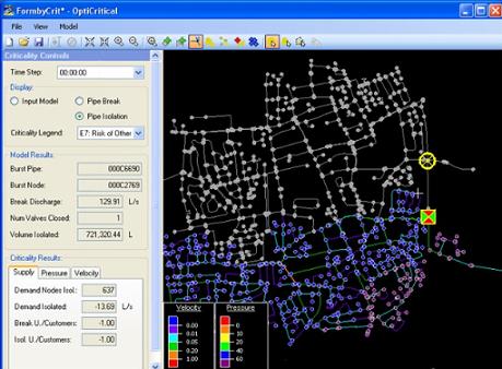
OptiCritical links a customized graphical user interface with a hydraulic simulation engine and is useful for system planning, maintenance, and incident management tasks. It is able to be applied to:

  • Pipe break simulation
  • Pipe isolation simulation
  • System-wide criticality and vulnerability review

OptiCritical simulates the impact on the system with regards to:

  • Ability to supply to customers
  • System pressures
  • System velocities
  • Water quality incidents (discoloration)
Tagged with: , , , ,

Update 11/09/2018: for some time now the application does not work due to changes in maps APIs.

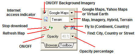
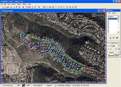
EPANet-Z (in free beta) from Zonum Solutions is a modified recompiled version of EPANet that adds the option to insert map and satellite images to the network’s backdrop. The program uses online services like Yahoo maps and Google maps to extract the images. From Zonum’s web site:

The use of a backdrop file brought new capabilities to EPANET. However, how do I create this file? how big this image can be? Is it already georeferenced? How about using an aerial photo or satellite image as a background?

What would you say, if you were told that you could access satellite images for the whole World and use them as a backdrop for EPANET, just by clicking a button?… I would say EPANET-Z.

EPANET 2.00.12 (3/5/08) was modified and re-compiled to display Online Maps/imagery as a background. EPANET-Z = EPANET + Online Maps (Yahoo Maps, Google Maps, Virtual Earth)

epanetz4

I have entered a small part of my neighborhood network to the program. Unfortunately the satellite image in my region is of poor quality (click the image to enlarge):

epanet-z-haifa-1

EPANet-Z at Zonum Solutions

Update 20/08/2010: for some reason the download link at Zonum Solutions for EPANet-z is broken. You can download it from here.

Tagged with: , , ,

Just a few days after posting about EPANET-BAM, Professor Choi sent a link to his AZRED program which simulates mixing at network’s fittings. This work was presented at WDSA 2008ֲ and available online [Development of a Comprehensive Solute Mixing Model (AZRED) at Junctionspdf].

Abstract:

Municipal water distribution networks consist of numerous cross-, tee-, and wye- junction connectors. In recent years, a series of experimental and numerical studies have sought to understand solute mixing at a cross junction. To address solute mixing phenomena at cross junctions, a fully functional computer program (AZRED v.1.0.0) was developed based on experimental results. The code was validated using a set of network-level experimental data. In the present study, comprehensive solute mixing patterns are investigated for various combinations of cross, double-tee, and wye junction connectors with different flow directions. Mixing patterns for various junction configurations are also visualized by means of dye injections at different flow ratios. These findings are integrated into a water quality solver (AZRED v.1.1.0) suitable for large-scale network simulations. Improved water quality models will be crucial in identifying optimal locations for water quality sensors, assessing models for early warning systems, and generating the exposure information needed for quantitative risk assessment.

Tagged with:

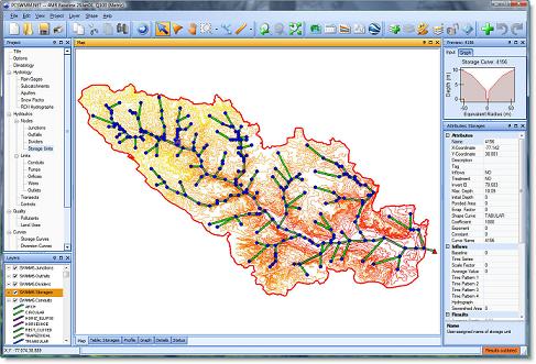
PCSWMM.NET, from CHI, is aֲ spatial decision support system for US EPA SWMM 5 urban drainage modeling (sanitary, storm, combined and watershed systems).

From CHI web site:

Built from the ground up around a modern, powerful GIS engine that works seamlessly with the latest GIS data formats, PCSWMM.NET implements advanced, intelligent tools for streamlining sewer collection system model development, optimization and analysis.With full support for the latest, fully dynamic US EPA SWMM5 hydrology/hydraulics engine, PCSWMM.NET provides a scalable (unlimited model sizes), and complete array of professional, enterprise level, urban drainage system modeling tools for an affordable price.

pcswmm_net

Modelling capabilities:

  • time-varying rainfall
  • evaporation of standing surface water
  • snow accumulation and melting
  • rainfall interception from depression storage
  • infiltration of rainfall into unsaturated soil layers
  • percolation of infiltrated water into groundwater layers
  • interflow between groundwater and the drainage system
  • nonlinear reservoir routing of overland flow
  • handle networks of unlimited size
  • use a wide variety of standard closed and open conduit shapes as well as natural channels
  • model special elements such as storage/treatment units, flow dividers, pumps, weirs, and orifices
  • apply external flows and water quality inputs from surface runoff, groundwater interflow, compute rainfall-dependent infiltration/inflow (RDII), dry weather sanitary flow (DWF), and user-defined inflows
  • utilize either kinematic wave or full dynamic wave flow routing methods
  • model various flow regimes, such as backwater, surcharging, reverse flow, and surface ponding
  • apply priority-based, dynamic control rules to simulate the operation of pumps, orifice openings, and weir crest levels.
  • dry-weather pollutant buildup over different land uses
  • pollutant washoff from specific land uses during storm events
  • direct contribution of rainfall deposition
  • reduction in dry-weather buildup due to street cleaning
  • reduction in washoff load due to BMPs
  • entry of dry weather sanitary flows and user-specified external inflows at any point in the drainage system
  • routing of water quality constituents through the drainage system
  • reduction in constituent concentration through treatment in storage units or by natural processes in pipes and channels.

New features:

  • Scenario analysis
  • Sub-model creation and model merging
  • Engineering audits (QA/QC)
  • Fill in missing data with PCSWMM Calculators
  • Dual drainage creation wizard
  • Time pattern creation and load allocation for DWF
  • Area weighting
  • Radar rainfall
  • Visual editors
  • Dynamic hydraulic grade line plots
  • Design storm generation
  • Data importing
  • Layer reprojection
  • Scatter plots
Tagged with: , , , , ,

fire-hydrant

Humberto Hernandez, of Oakland, never saw what hit him

It was a 200 pound flying fire hydrant knocked into the air when an SUV driver lost control and her vehicle struck the hydrant propelling it into the air and the the back of the head of Hernandez.

After nailing Hernandez in the back of the head the flying fire hydrant continued on eventually hitting a fence about 20 feet past the dead man.

Source: Today In The USA

Tagged with:

mufti-hitlerOn 1941 the Arab Mufti of Jerusalem Haj Amin al-Husseini met with Adolf Hitler and discussed ways to ‘solve the Jewish problem’. Three years later the Nazis and the Arabs of Palestine planned to poison the drinking water in Tel-Aviv with Arsenic poison.

Four years before the establishment of the State of Israel the Nazis and the Arabs of Palestine planned to poison the water of Tel Aviv with Arsenic poison, and only as a result of an early intelligence report by a British spy who was working undercover in the German military intelligence service, the plan was never carried out.

Hezbollah planning to poison rivers that flow into Israel

After the Second Lebanon War on 2006 the Israeli Defense Ministry received some disturbing information concerning the water in Israel. According to the information, Hezbollah is attempting to sabotage the quality of the water in Israel by pouring poison from the Lebanese side of the border to the rivers that flow to the Kinneret (Sea of Galilee).
After an evaluation of the situation a decision was made by the Mekorot Company – a water company that provides 90% of the drinking water for the inhabitants of Israel – and by the Defense Ministry, to put special types of fish into the Snir River, close to the Lebanese border. Each type of fish responds to different types of poisons that could appear in the water. Mekorot is inspecting the activity of the fish from a control room. If something happens to one of the fish it gives an immediate indication that the water is poisoned and by which type of poison. The security of water is not abnormal. Mekorot is taking the same measures in other locations in Israel in order to prevent water poisoning including strategic apparatuses in the south and electronic devices in sensitive areas.

Source: isracast

Tagged with: ,