EPANET-Z – add online maps and satellite images to EPANET
Update 11/09/2018: for some time now the application does not work due to changes in maps APIs.
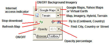
EPANet-Z (in free beta) from Zonum Solutions is a modified recompiled version of EPANet that adds the option to insert map and satellite images to the network’s backdrop. The program uses online services like Yahoo maps and Google maps to extract the images. From Zonum’s web site:
The use of a backdrop file brought new capabilities to EPANET. However, how do I create this file? how big this image can be? Is it already georeferenced? How about using an aerial photo or satellite image as a background?
What would you say, if you were told that you could access satellite images for the whole World and use them as a backdrop for EPANET, just by clicking a button?… I would say EPANET-Z.
EPANET 2.00.12 (3/5/08) was modified and re-compiled to display Online Maps/imagery as a background. EPANET-Z = EPANET + Online Maps (Yahoo Maps, Google Maps, Virtual Earth)

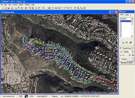
I have entered a small part of my neighborhood network to the program. Unfortunately the satellite image in my region is of poor quality (click the image to enlarge):
Update 20/08/2010: for some reason the download link at Zonum Solutions for EPANet-z is broken. You can download it from here.

This is a great facility that is incorporated . One more request is printing capabilities of the EPAnet has to be oncreased as it allows only the things that are viewable on screen only. So why not we can export the output file to AutoCAD like softwares for proper presentation.
i want program
i want to use the programme epanet z
please give me this program
I am impressed with the capabilities. How can I get the software?
Hello
I’m still a novice on EPANET but I got a problem on the projection system. I wish spend EPANET to EPANET Z without problem. But this is not the case ! Under EPANET, the projection system is the Lambert 2 and under EPANET Z need WGS84. I try to transfer the file .net in .shp with epa2GIS, then to re-project, but it created 5 files .shp. I canג€™t perform the opposite operation shp2epa. Have you any idea?
Thank you in advance!
SEND SEND ME THIS PROGRAM PLS
Programme EPANET Z
http://www.zonums.com/epanetz.html
I want to download the EPANETMSX for modelling chlorine decay an reduction of TTHM with scheduling and location of booster chlorinaion for DWDS. How to download EPANETMSX
roopali – the info is here:
http://www.epa.gov/nrmrl/wswrd/dw/epanet.html#extension
Anyone else having problems downloading EPANET Z? There seems to be a problem with the ‘Download Program’ on EPANET Z page of the Zonums site and so attempts to access ‘http://www.zonums.com/software/softdown/softdown_down.php?id=EPANETZ’ result in a ‘Missing ID’ error message.
Hello, I have the same problem as Will, does anyone have a solution to download it?
I have the same problem. Is there another source to download tpanet z?
Thank you, download is working now.
It seems that something went wrong again, sadly, the “missing-id” is back… Is epanet-z still downloadable somewhere else?
I want to please you if EPANET z.
Hi, where can I download Epanet-Z, i get missing ID when I try to download
See the note at the end of the post. you can try downloading from here:
http://www.water-simulation.com/wsp/wp-content/uploads/2008/12/Epanet-Z.zip
This is awesome for EPANET.
http://georepository.com/crs_3044/ETRS89-TM32.html
Hello
I live in Os, Norway, and have used EPANET for many years modelling and analycing the municipal drinking water distribution system of Os. I was pleased to find this blog about epanet-z, as it seems to be alive in des. 2012. May be I can use epanet-z to improve the backdrops of our epanet model.
Downloading and installing was OK via the updatetd links on this blog.
The challenge is to make internet backdrops work with a metric system. Our epanet model is already designed with metric coordinates in this system: http://georepository.com/crs_3044/ETRS89-TM32.html
Primarily I would like to keep the coordinates of the model and adapt the backdrop. Then changes in the model can still be done without converting anything.
Another option (less good) can be to convert the model to the coordinates of the backdrop system. Anyway it has to be in metric system.
I tried to change to metric system in the epanet-z, but the backdrop disappeared imediately.
Does anyone have a solution to this problem? I guess it would be helpful to all users in Europe.
Yours
Finn Harald Eliassen
Bsc.
Hei
Jeg kan lage wmf backdrop til deg i helt nøyaktig målestokk.
Trenger da digitalt kartverk i sosi, quadri eller shape.
Si fra hvis du ønsker det.
Hello,
I used this sofware a few times.
What I have done is change my original metric coordinates in Portuguese Datum to latitude and longitude. You also need to change the units of the coordinates to Degrees.
I hope this comment is useful.
Regards,
Nuno Dias
how do i transfer node elevations from autocad 3D to epanet without entering the elevations manually (one by one). can epanet pick the elevations automatically
Not that I know of. Can you export the elevations to a file?
Great stuff!!!
Thank you for this and for all tools inside toolbox…
Hi,
as I run the EPANET Z.exe an error shows up: an error has occurred in the script on this page. can you pls help me solving this problem?
and also I don know how to transfer the X and Y coordinated into degrees, appropriate for EPANET Z?
Regards,
Arefe, Safa
Arefe, there was a problem with the program. See this post:
http://www.water-simulation.com/wsp/2014/08/18/a-possible-privacy-issue-with-epanet-z/
thanks a lot, I saw the link, now it works using Bing maps, but the maps for my country (Iran) is so general and I do need more detailed maps, can I use Google maps instead of Bing’s?
Regards
Arefe, Safa
Yes, you can select Google maps from the drop-down box on the right hand side of the screen.
Hi can anybody help me? is epanet z still working. i downloaded it but navigation to the coordinates that i want to use id=s very difficult and i cant edit the map when working with google maps only yahoo? the browser part also looks different and seems to need certain extensions?
Yes, it works.
There is a small change in the program, when you select Yahoo maps its actually uses Bing maps and should work fine.
What area are you using?
I tried both yahoo and google maps but it doesnt allow me to enter the coordinates. i have to scroll using the arrows and as soon as i close and save and reopen the program it starts with a zoomed out view of usa. https://www.dropbox.com/s/5gxlg0g9ri8hfwj/Screenshot%202014-09-04%2008.49.02.png?dl=0
sorry the link i posted now was for virtual earth. here is the one for yahoo maps. i cant get it to use the little hand to navigate to a different country. I live in South Africa and need the layout of a township for a project. https://www.dropbox.com/s/v7tpoees8x1fcnr/Screenshot%202014-09-04%2008.53.41.png?dl=0
I WOULD LIKE TO USE EPANET Z
I have a problem with epa2gis I can not install someone can you help me
Hello,
I’m trying to use EpanteZ but it is not working correctly. I downloaded the zip file and started to work from there but some buttons are missing in the window bellow the browser and some script errors are always showing.
Besides, when I save the file and reopen, I cannot reach the network using Google maps, only with yahoo…
Is anyone having these problems too?
Is there any problem with the zip file?
Thank you!
CS, I have the issues but there is no problem with the ZIP file – it is the one received from the author. Will try to contact him again.
Thanks Elad. I think this application is very interesting and I really need to use it but, right now, it just doesnt work with google maps…
If you know any solution for this, please let me know! Thank you in advance!
CS
Good Day,
I am Luvhimba Ramulongo i need someone to help me with analzing a water distribution system, and i am willing to pay for it. I am a student at the university of Venda in South Africa. I am studying environmental science and have no engineering background. Your help will be truly appretiated.
Regards
GOOD Day,
I am Luvhimba Ramulongo i need someone to help me with analzing a water distribution system, and i am willing to pay for it. I am a student at the university of Venda in South Africa. I am studying environmental science and have no engineering background. Your help will be truly appretiated.
Regards
send we can look at it…for free
Hi, where can I download Epanet-Z, i get missing ID when I try to download?
See the note at the end of the post. you can try downloading from here:
http://www.water-simulation.com/wsp/wp-content/uploads/2008/12/Epanet-Z.zip
It’s working,thanks!You’re the best!
When I try to load google maps it crashes with message “script error”. Anybody has an idea of how to resolve this?
Thanks!
V.
Are you using Yahoo Maps from the drop-down box on the right window?
I downloaded trial epanet z but the new added interface for online maps and images missed some icons:fly to(country,continent),find city or street. terrain,internet indicator,stop download,refresh map.
Hi all,
epanet z cannot connect to the internet and the zonums.com website is also not connected. Please help me! I am very attached to the hydraulic model from epanet to google maps.
Thanks!
Hi all,
epanet z cannot connect to the internet and the zonums.com website is also not connected. Please help me! I am very attached to the hydraulic model from epanet to google maps.
Thanks!