ModTech
ModTech enables you to model groundwater flow and contaminant transport within a real-world geographic environment. ModTech has plenty of math power under its hood and – to extend the automotive metaphor – the steering and gear-box are pure Win-32: flexible, intuitive, and comfortable to the touch. This seamlessly integrated modeling & GIS environment enables you to:
- Design the model grid graphically or analytically
- Assign properties and introduce boundary conditions using a variety of methods
- Transform geographical objects or entire maps to model grids
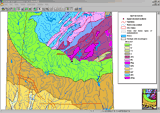
- Visualize input parameters in 2D or 3D
- Run groundwater flow and contaminant transport simulations using common or proprietary solvers
- Automatically receive data for model calibration
- Display and interpret the modeling results in 2D and 3D
- Transform the modeling results to geographic objects
- Exchange input and output data with common GIS, CAD, and graphic formats
For more information see GEOLINK web site.
i wish to use this program