Civil Designer – Water
From CIVIL DESIGNER web page:
Civil Designer is the design system created by civil engineers for civil engineers. Water is a powerful, yet easy to use module for the analysis and extended time simulation of fluid handling networks consisting of pipes, valves, reservoirs and pump stations.
With the Water module you can:
- Import data from various sources such as ASCII tables, spreadsheets, dBase or MS Access tables as well as DWG/DXF files.
- Graphical interaction allows you to easily insert nodes and links, make changes to an existing layout by moving a node, change the flow direction, and query or edit a link with a click of the mouse.
- View the network with a bitmap or cadastral backdrop, or display the site contours and slope shading to decide on optimum network layout.
- Analyse suburbs separately and combine new and existing models to simulate the complex system of networks that are often found in modern towns and cities. The comprehensive network design will take into account the relationship between different branches.
- Time-based demand patterns may be defined for different categories of water usage. Each draw-off point may have a different demand pattern.
- The impact of extensions to the network, increased demand, imposition of water restrictions, power failures, major pipe breaks and empty reservoir conditions may be readily determined.
- Attach external water consumption tables and compare the measured usage to the modelled consumption to calibrate the demand or identify problem areas in the network.
- Up to 8 pumps may be handled in each pump station. The pumps are configured in parallel and may be controlled by pressure, water level or be time-based (on/off at certain times).
- Valves may be controlled manually, by pressure, by flow, or by level. Reservoirs may have any shape ג€” you can select one of the most common shapes or define the water depth versus volume for a particular reservoir.
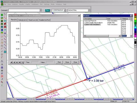
- Display the results of an analysis graphically by colour according to calculated results, in tables, or on time-based curves.
- Generate long sections with the ground profile automatically extracted from the supporting digital terrain model.
For more information see Civil Designer – Water web page.
Well we are a civil campagny in flow and we are very interrested to you simulationj package. We have the intention to show it to differentes campagnies and center ofhydraulic school, we need to make a demontration for interrested people, if the results are concluantes, so we shall be happy to commercial it in algeria.
Idid ready explained our idea to mister Elad Salomons
my respects
Djilali Beskri
Interesting application.