WinLoG 4.0
From GAEA Technologies web site:
We are very pleased to announce that WinLoG Version 4 has been released. This upgrade has taken over two years to develop and represents the culmination of many of our users and internal ideas for enhancements.
The geographical information system feature added in version 4 displays a location map for the project showing the boreholes, cross-sections, and any surface features. This feature makes it easy to visualize your project and can be used to print a location map of the project. To edit a borehole all you need to do is click on it in the location map.
There are many new and exciting features in version 4, below is a list of some of them:
- Graphical Information System (GIS) for displaying and picking boreholes and cross-sections in WinLoG with WinFence. GIS can also display site features and import AutoCAD files. This borehole location map can also be printed and included in reports.
- Several types of project reports can be generated for all data in a project. Reports include general data, lithology data, sample data, graph data, water level data, etc.
- Deviated boreholes can be entered and displayed in true depth. Several methods for calculating true depth are supported. Deviation readings can be entered manually or imported from a file.
- Tables (ex. Water Level Readings) can be displayed anywhere on boring logs and templates.
- Templates and projects can have password locks that can be used to restrict changes to a template and access to a project.
- Can import data in several formats including Excel, AGS, GTGS, LogPlot, and gINT.
- Data in Excel can be imported into all the logs in a project at the same time. This can be used to import the survey data for all the boreholes from a spreadsheet.
- Borehole data can now be exported to AGS and Excel.
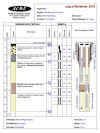
- Continuous logs are supported. These logs span several pages and do not have any page breaks.
- A new column has been added to show percent splits. This is used to show the percentages of different lithologies in a layer.
- Another new column has been added to show core photos at various depths.
- Program can now automatically update itself to the most recent version. The program searches GAEA Technologies website for any new upgrades.
- Program now has online technical support, where it can email technical support all relevant files and information if there is a problem.
- Project databases can be compressed to save disk space and speed up data access.
- All of the WinLoG databases are automatically backed up and can be easily restored.
For more information see GAEA Technologies web site.
Things are working fine. Can a change a template on a open boring log in Winlog4?
Finally found the Change Template button. Tried it in a open boring log and getting the error? WinLog4 error….Access violation at address 40004B3C in module “Vd50.bpl”. Read of address 0000040A.
Thanks.
BK Gopal