GISRed INTEGRATION OF EPANET 2 IN ARCVIEW GIS 3.2
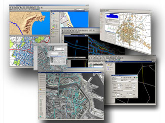
GISRed is a customized extension to ArcView GIS 3.2 oriented to the modeling and calibration of water distribution networks which integrates all the capabilities of the widely used hydraulic modeling software EPANET 2.0.
The reduced version offers:
- A total integration ArcView GIS 3.2 – EPANET 2
- CAD, Shapefile and EPANET Import
- Real-time automatic TOPOLOGY generation
- Network Connectivity Check (detection of unconnected parts of the network and spanning tree)
- Use of Pipe material(eg. for calibration purposes)
- Hydraulic and Quality Property Editors
- Control rules, Curve and Pattern Editors
- Editing tools, Group Edit
- Spatial Analysis: Automatic elevation Interpolation
- Network Queries (Themes classified by diameter, roughness, demand, elevation,…)
- Interactive Overview Map
- Interactive themes (street theme, auxiliary element theme,…) and (CAD, aerial photographs, etc)
- Connection with the EPANET 2 toolkit to perform extended period simulation of hydraulic and quality behaviour
- Retrieval and presentation of simulation results
- Management of multiple simulation scenarios
At this point, the reduced version does not offer the following functionalities:
- Automatic Demand Allocation
- Automatic Calibration using genetic algorithms
- Spatial verification tools
- Error Navigator
This project has been developed within the REDHISP group which belongs to the Institute of Water & Environmental Engineering of the Polytechnic University of Valencia.
i want to learn the waternet simulation and enhance the performance of water supply.
gostaria de mais informaחץes em portugues sobre o programa e como se faz a aplicaחדo dele e o sistema novo e antigo de agua
I’m interested with “GISRed INTEGRATION OF EPANET 2 IN ARCVIEW GIS 3.2ג€ and I want to learn more about this software for education uses. especially the way to display Epanet output spatially.
For details please contact Prof. Fernando Martinez: fmartine@hma.upv.es
I want to Epanet
Por favor, fiz o download do gisred, mas nao consegui manusea-lo. Esta extensֳ£o converte arquivos de arcview para epanet correto? eu quero converter uma rede completa do epanet para o arciew com todas as informaֳ§ֳµes, ֳ© possivel?
Sir,
I am doing my Mtech -Thesis in VJTI, Mumbai.
I have selected “Deveopment of GIS based Hydraulic model for water sypply system network”. I want to do It using EPANET and GISRed and ArcView
Can You Please give me few tips?
vnbapat@gmail.com
I want to learn about GIS integerates with epanet and I want to know function and use of GIS integrates epanet. Where can I find the software.. ? thanks Sirs,
I want know about, is there Gis runs with epanet or integration both of them ?, so if we can know the rest of water pressure at the customers from the network map on the computer and also we can add some new customers by seeing the rest of water pressure .
thanks sirs
could you give information about it ?
I downloaded GisRed to use it for one of my project. I got stuck at adding the pump curve and demand data to the programme. It may be a bug in the programme or the extension is not properly installed on my computer.
Most of the buttons on the add curve and pattern dialogue boxes are grayed out and do not provide any option for addition of data.
Alternately, can someone please provide the format of the text file for cure and pattern data so that it can be loaded to the programme.
Your help will be much appreciated. Thanks.
Regards
Ken
Sir,
I would like to get this program for my career. This program can helpful for my job. I was use another program for converse shapefile to epanet but the length of pipe not correct and can’t import elvation, diameter, and demand to epanet, may you suggestion me for the program can do it. Please, reply and give for link on the program. My e-mail: nitchakan_auy@hotmail.co.th
Thank you so much
Eve
I also downloaded GisRed. but I got stuck at adding the pump curve and demand data to the program.
if someone can help me please.
Thanks.